 |
 © ©
|  |
 |
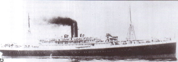
| Vessel Type: | Passenger Steamer | Location: | Co. Wexford |
| Date of Loss: | 17th March 1917 | Place: | Great Saltee |
| Cause of Loss: | Torpedoed | Boat Dive from: | Kilmore Quay |
| Charted Depth: | 58m | Irish O.S. Map: | Discovery Series No. 77 |
| Height of Wreck: | 10m | Admiralty Chart No: | 2740 and/or 1410 |
| Hull Material: | Steel | Latitude (approx.): | 51° 56' North |
| Type of Seabed: | Longitude (approx.): | 07° 09' West | |
| Average Visibility: | 20 - 55m | Convert Lat. & Long. to - | Decimal - CLICK HERE |
| Image available? | Yes - see below | Diving Experience: | Very Experienced |
| Diving Information: |
|
| Historical Information: |
|
© by kind permission of wrecksite.eu web site
Click
HERE
for INFOMAR* Side-Scan image |
SOURCE
PUBLICATIONS :
|
"Dictionary
of Disasters at Sea during the Age of Steam 1824
- 1962" | by | Charles Hocking |
| London Stamp Exchange 1989 - ISBN: 0948130474 | ||
| "SubSea
Magazine" | by | Irish Underwater Council |
OTHER
SOURCES :
|
*source
- Geological Survey of Ireland | - | Internet (2020) |
| Guðmundur
Helgason's U-Boat
web site | - | Internet (2014) |
| |
Last update - 23-Dec-2020
|
|
A page from "www.irishwrecksonline.net" ©