 |
 © ©
|  |
 |
| Vessel Type: | Steamer | Location: | Co. Cork |
| Date of Loss: | 17th September 1924 | Place: | Stag Rocks, Toe Head |
| Cause of Loss: | Struck rocks | Boat Dive from: | Baltimore |
| Charted Depth: | 20m | Irish O.S. Map: | Discovery Series No. 87 & 89 |
| Height of Wreck: | Scattered | Admiralty Chart No: | 2092 and/or 2424 |
| Hull Material: | Steel | Latitude (approx.): | 51° 27' 55" North |
| Type of Seabed: | Rocks & kelp | Longitude (approx.): | 09° 13' 36" West |
| Average Visibility: | 10m | Convert Lat. & Long. to - | Decimal - CLICK HERE |
| Image available? | Yes - see below | Diving Experience: | Experienced |
| Diving Information: |
|
| Historical Information: |
|
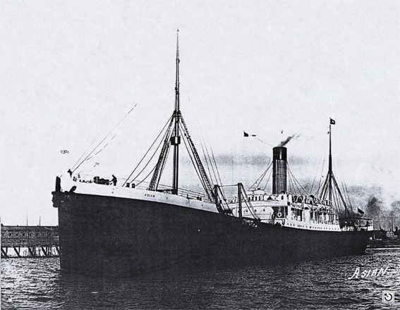
© by kind permission of Dr. Edward J. Bourke
| Source Publications: |
| "Dictionary
of Disasters at Sea during the Age of Steam 1824 - 1962" |
by | Charles Hocking |
| London Stamp Exchange 1989 - ISBN: 0948130474 | ||
|
"Irish
Wrecks Database" | by | Roy Stokes & Liam Dowling |
|
"Shipwrecks
of the Irish Coast 1105 – 1993" |
by | Dr. Edward J. Bourke |
| Edward J. Bourke 1994 - ISBN: 0952302705 | ||
|
"Underwater
Ireland Guide to Irish Dive Sites" |
by | Irish Underwater Council |
| CFT 1999 - ISBN: 0948283025 |
| Other Sources: |
| Aquaventures |
- | Internet (2001) |
| |
Last update - 05-Dec-2005
|
|
A page from "www.irishwrecksonline.net" ©