 |
 © ©
|  |
 |
| Vessel Type: | 4 Masted Barque | Location: | Co. Kerry |
| Date of Loss: | 23rd November 1910 | Place: | Dromgour Point |
| Cause of Loss: | Foundered in fog | Boat Dive from: | Valentia Island |
| Charted Depth: | 10 - 25m | Irish O.S. Map: | Discovery Series No. 83 |
| Height of Wreck: | Scattered | Admiralty Chart No: | 2125 |
| Hull Material: | Steel | Latitude (GPS): | 51° 51' 44.4" North |
| Type of Seabed: | Rocks and sand | Longitude (GPS): | 10° 23' 01.8" West |
| Average Visibility: | 10 - 15m | Convert Lat. & Long. to - | Decimal - CLICK HERE |
| Image available? | Yes - see below | Diving Experience: | Novice |
| Diving Information: |
|
Historical Information: |
|
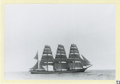
A.D. Edwardes Collection
© by kind permission of State Library of South Australia - PRG 1373/6/67
| Source Publications: |
| "Irish
Wrecks Database" | by | Roy Stokes & Liam Dowling |
|
"Shipwreck
Index of Ireland" |
by | Richard & Bridget Larn |
| Lloyd's Register - Fairplay Ltd 2002 - ISBN: 1900839970 | ||
|
"Shipwrecks
of the Irish Coast 932 - 1997" |
by | Dr. Edward J. Bourke |
| Edward J. Bourke 1998 - ISBN: 0952302713 | ||
|
"Underwater Ireland Guide to Irish Dive Sites" |
by | Irish Underwater Council |
| CFT 1999 - ISBN: 0948283025 |
| Other Sources: |
| Des
Lavelle | - | Valentia Diving Centre (1986) |
Lars
Bruzelius | Internet (2002) | |
| Paschal
Dower | - | SubSea Magazine Autumn 2010 |
| |
Last update - 01-Jul-2020
|
|
A page from "www.irishwrecksonline.net" ©