 |
 © ©
|  |
 |
| Vessel Type: | Steamer | Location: | Co. Donegal |
| Date of Loss: | 24th August 1940 | Place: | Malin Head |
| Cause of Loss: | Torpedoed | Boat Dive from: | Culdaff |
| Charted Depth: | 52m | Irish O.S. Map: | Discovery Series No. 3 |
| Height of Wreck: | 7m | Admiralty Chart No: | 2811 and/or 2723 |
| Hull Material: | Steel | Latitude (GPS): | 55° 31' 33.60" North |
| Type of Seabed: | Gravel | Longitude (GPS): | 07° 15' 15.54" West |
| Average Visibility: | 20m | Convert Lat. & Long. to - | Decimal - CLICK HERE |
| Image available? | Yes - see below | Diving Experience: | Very Experienced |
| Diving Information: |
|
| Historical Information: |
|
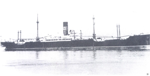
via Sandy Roberts
All rights respectfully acknowledged
Click
HERE
for INFOMAR* Side-Scan image |
Source
Publications: |
| "Dictionary
of Disasters at Sea during the Age of Steam 1824 - 1962" |
by | Charles Hocking |
| London Stamp Exchange 1989 - ISBN: 0948130474 | ||
| "Shipwreck
Index of Ireland" |
by | Richard & Bridget Larn |
| Lloyd's Register - Fairplay Ltd 2002 - ISBN: 1900839970 | ||
| "Shipwrecks
of the Irish Coast 932 - 1997" |
by | Dr. Edward J. Bourke |
| Edward J. Bourke 1998 - ISBN: 0952302713 | ||
|
"Shipwrecks
of the Irish Coast 1105 – 1993" |
by | Dr. Edward J. Bourke |
| Edward J. Bourke 1994 - ISBN: 0952302705 |
Other
Sources: |
*source
- Geological Survey of Ireland | - | Internet (2020) |
| via email (2012) | ||
| Norman
Woods | - | Portstewart SAC (2000) |
| Royal
Navy | - | Hydrographic Department (1970) |
|
|
Last update - 16-Nov-2020
|
|
A page from "www.irishwrecksonline.net" ©