 |
 © ©
|  |
 |
| Vessel Type: | Steam Coaster | Location: | Co. Down |
| Date of Loss: | 14th January 1942 | Place: | Cranfield Point |
| Cause of Loss: | Stranded and wrecked | Boat Dive from: | Kilkeel |
| Charted Depth: | 10m | Irish O.S. Map: | Discovery Series Nos. 29 & 36 |
| Height of Wreck: | Broken up | Admiralty Chart No: | 44 |
| Hull Material: | Steel | Latitude (approx.): | 54° 01' 03" North |
| Type of Seabed: | Gravel and sand | Longitude (approx.): | 06° 01' 55" West |
| Average Visibility: | 10 - 12m | Convert Lat. & Long. to - | Decimal - CLICK HERE |
| Image available? | Yes - see below | Diving Experience: | Experienced |
| Diving Information: |
|
Historical Information: |
|
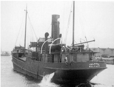
© by kind permission of photoship web site
| Source Publications: |
"Irish
Wrecks Database" | by | Roy Stokes & Liam Dowling |
|
"Shipwreck
Index of Ireland" |
by | Richard & Bridget Larne |
| loyd's Register - Fairplay Ltd 2002 - ISBN: 1900839970 | ||
|
"Shipwrecks
of the Irish Coast 1105- 1993" |
by | Dr. Edward J. Bourke |
| Edward J. Bourke 1998 - ISBN: 0952302705 |
| Other Sources: |
| - | National Museums NI (2020) |
| |
Last update - 03-Jun-2020
|
|
A page from "www.irishwrecksonline.net" ©