| |
 © ©
| |
| Vessel
Type: | Steam
Coaster | Location: | Co.
Antrim | | Date
of Loss: | 10th
September 1915 | Place: | Fair
Head | | Cause
of Loss: | Ran
aground | Boat
Dive from: | Ballycastle |
| Charted
Depth: | 5m | Irish
O.S. Map: | Discovery
Series No. 5 | | Height
of Wreck: | Scattered | Admiralty
Chart No: | 2798 |
| Hull
Material: | Iron | Latitude
(approx.): | 55°
13' 45" North | | Type
of Seabed: | | Longitude
(approx.): | 06°
09' 00" West | | Average
Visibility: | 6
- 10m | Convert
Lat. & Long.
to - | Decimal
- CLICK
HERE | | Image
available? | Yes
- see below
| Diving
Experience: | Experienced
Novice | - Very
broken up.
- Lies quite close inshore,
in about 5m. on the West side of Fair Head.
- Lot
of metal up on the rock opposite site.
- Portholes
lying around.
- Flood tide runs
quite close inshore in this area.
|
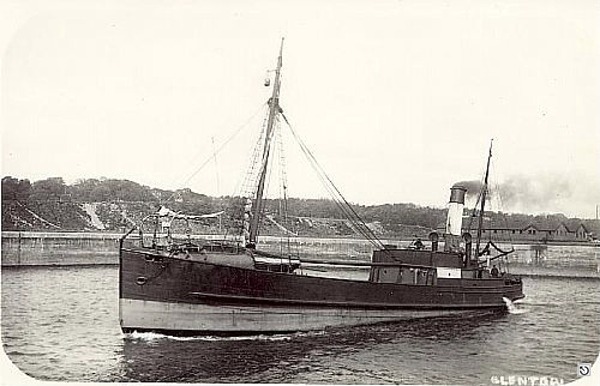
- Built
in 1895 by J McArthur, Paisley, she was owned by H.M. McGildowney, Ballycastle
Shipping Co., she grossed 144 tons, and measured 98 x 19 x 9ft..
- While
bound for Ballycastle with a cargo of coal, she went too close inshore and was
forced onto a reef by the flood tide.
- Attempts
to free her failed, and she broke her back a few days later.
|
©
by kind permission of clydeships
web
site "Shipwreck
Index of Ireland" | by | Richard
& Bridget Larn | | Lloyd's
Register - Fairplay Ltd 2002 - ISBN: 1900839970 |
| "The
Harsh Winds of Rathlin" | by | Tommy
Cecil | |
Impact Printing 1990 - ISBN:
0948154659 |
|
|
Last
update - 03-Jul-2020

|
|
|