 |
 © ©
|  |
 |
| Vessel Type: | Steam Freighter | Location: | Co. Donegal |
| Date of Loss: | 7th October 1943 | Place: | Tranarossan North of Downings |
| Cause of Loss: | Ran aground | Boat Dive from: | Doagh Bay or Downings |
| Charted Depth: | 25m | Irish O.S. Map: | Discovery Series No. 2 |
| Height of Wreck: | Scattered | Admiralty Chart No: | 2699 |
| Hull Material: | Steel | Latitude (approx.): | 55° 56' 48" North |
| Type of Seabed: | Rocky | Longitude (approx.): | 08° 38' 30" West |
| Average Visibility: | 10 - 15m | Convert Lat. & Long. to - | Decimal - CLICK HERE |
| Image available? | Yes - see below | Diving Experience: | Experienced Novice |
| Diving Information: |
|
| Historical Information: |
|
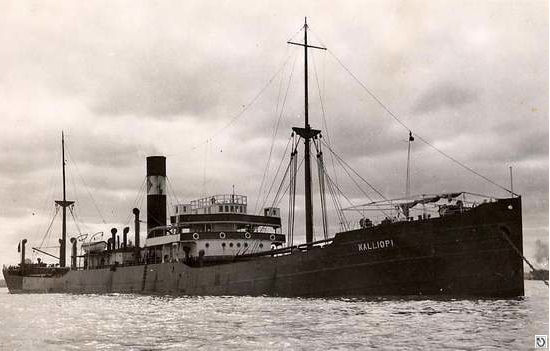
© by kind permission of wrecksite.eu web site
(thought to be the correct vessel)
| Source Publications: |
| "Donegal
Shipwrecks" |
by | Ian Wilson |
| Impact Printing 1998 - ISBN: 094815456X | ||
| "Shipwreck
Index of Ireland" |
by | Richard & Bridget Larn |
| Lloyd's Register - Fairplay Ltd 2002 - ISBN: 1900839970 | ||
| "Shipwrecks
of the Irish Coast 932 - 1997" |
by | Dr. Edward J. Bourke |
| Edward J. Bourke 1998 - ISBN: 0952302713 | ||
| "Shipwrecks
of the Irish Coast 1105 – 1993" |
by | Dr. Edward J. Bourke |
| Edward J. Bourke 1994 - ISBN: 0952302705 | ||
|
"Shipwrecks
of the Irish Coast 1582 - 2000" |
by | Dr. Edward J. Bourke |
| Edward J. Bourke 2000 - ISBN: 0952302721 |
| Other Sources: |
Randal
Armstrong | - | Castlereagh SAC (1984) |
| Francis
Hood | - | N.I. Dive (1985) |
| |
Last update - 05-May-2004
|
|
A page from "www.irishwrecksonline.net" ©