 |
 © ©
|  |
 |
| Vessel Type: | Trawler | Location: | Co. Donegal |
| Date of Loss: | 1997 approx. | Place: | St. John's Point |
| Cause of Loss: | Sunk on purpose | Boat Dive from: | Killybegs or Teelin |
| Charted Depth: | 37m to 50m | Irish O.S. Map: | Discovery Series No. 10 |
| Height of Wreck: | 10m | Admiralty Chart No: | 2702 and/or 2725 |
| Hull Material: | Steel | Latitude (GPS): | 54° 34' 59.52" North |
| Type of Seabed: | Rocks | Longitude (GPS): | 08° 30' 01.62" West |
| Average Visibility: | 15 - 20m | Convert Lat. & Long. to - | Decimal - CLICK HERE |
| Image available? | Yes - see below | Diving Experience: | Experienced |
| Diving Information: |
|
| Historical Information: |
|
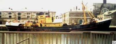
© by kind permission of Trawlerphotos web site
Click
HERE
for INFOMAR* Side-Scan image |
| Other Sources: |
*Geological
Survey of Ireland | - | Internet site (2020) |
| Malcom
Houston | - | Donegal SAC 2004 |
| Keith
Farrell | - | Newry & Mourne SAC 2005 |
| Gerry
Brown | - | Newry & Mourne SAC 2006 |
| |
Last update - 08-Nov-2020
|
|
A page from "www.irishwrecksonline.net" ©