 |
 © ©
|  |
 |
| Vessel Type: | US Navy Liberator aircraft | Location: | Co. Kerry |
| Date of Loss: | 27th February 1944 | Place: | Skellig Michael |
| Cause of Loss: | Struck mountain | Boat Dive from: | Valentia Island |
| Charted Depth: | 10 - 25m | Irish O.S. Map: | Discovery Series No. 83 |
| Height of Wreck: | Scattered | Admiralty Chart No: | 2125 |
| Hull Material: | Steel & aluminium | Latitude (approx.): | 51° 46' North approx. |
| Type of Seabed: | Rocks and sand | Longitude (approx.): | 10° 32' West approx. |
| Average Visibility: | 10 - 15m | Convert Lat. & Long. to - | Decimal - CLICK HERE |
| Image available? | yes - see below | Diving Experience: | Novice |
| Diving Information: |
|
| Historical Information: |
|
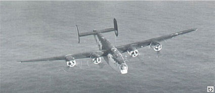
"Over the Bay" - by George Koshiol ©
A typical wartime USN Liberator based in the UK around 1944
© by kind permission of Dunkeswell Memorial Museum

Squadron Emblem
© by kind permission of Dunkeswell Memorial Museum
| Source Publications: |
| "Irish
Wrecks Database" | by | Roy Stokes & Liam Dowling |
|
"Underwater
Ireland Guide to Irish Dive Sites" |
by | Irish Underwater Council |
| CFT 1999 - ISBN: 0948283025 |
| Other Sources: |
|
Des
Lavelle | - | Valentia Diving Centre (1986) |
| |
Last update - 10-Feb-2006
|
|
A page from "www.irishwrecksonline.net" ©