 |
 © ©
|  |
 |
| Vessel Type: | 38 Gun Frigate | Location: | Co. Donegal |
| Date of Loss: | 4th December 1811 | Place: | Lough Swilly |
| Cause of Loss: | Ran aground | Boat Dive from: | Buncrana or Portsalon |
| Charted Depth: | Irish O.S. Map: | Discovery Series No. 2 & 3 | |
| Height of Wreck: | Admiralty Chart No: | 2811 and/or 2723 | |
| Hull Material: | Wood | Latitude (approx.): | 55° 17' 00" North |
| Type of Seabed: | Longitude (approx.): | 07° 35' 00" West | |
| Average Visibility: | Convert Lat. & Long. to - | Decimal - CLICK HERE | |
| Image available? | Yes - see below | Diving Experience: |
| Diving Information: |
|
| Historical Information: |
|
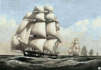
© by kind permission of Jim Woods at myirelandpast web site
| Source Publications: |
| "Donegal
Shipwrecks" |
by | Ian Wilson |
| Impact Printing 1998 - ISBN: 094815456X | ||
|
"Shipwreck
Index of Ireland" |
by | Richard & Bridget Larn |
| Lloyd's Register - Fairplay Ltd 2002 - ISBN: 1900839970 | ||
| "Shipwrecks
of the Irish Coast 1105 - 1993" |
by | Dr. Edward J. Bourke |
| Edward J. Bourke 1994 - ISBN: 0952302705 | ||
|
"Shipwrecks
of the Irish Coast 1582 - 2000" |
by | Dr. Edward J. Bourke |
| Edward J. Bourke 2000 - ISBN: 0952302721 |
| Other Sources: |
| Royal
Navy | - | Hydrographic Department (1970) |
|
|
Last update - 05-May-2004
|
|
A page from "www.irishwrecksonline.net" ©