 |
 © ©
|  |
 |
| Vessel Type: | Cargo Steamer | Location: | Co. Wexford |
| Date of Loss: | 24th April 1903 | Place: | Tuskar Rock |
| Cause of Loss: | Struck rocks | Boat Dive from: | Kilmore Quay |
| Charted Depth: | 8m | Irish O.S. Map: | Discovery Series No. 77 |
| Height of Wreck: | 4.5m | Admiralty Chart No: | 1787 and/or 2740 |
| Hull Material: | Steel | Latitude (approx.): | 52° 12' 20" North |
| Type of Seabed: | Longitude (approx.): | 06° 12' 33" West | |
| Average Visibility: | 8 - 10m | Convert Lat. & Long. to - | Decimal - CLICK HERE |
| No image available. | Diving Experience: | Novice |
| Diving Information: |
|
| Historical Information: |
|
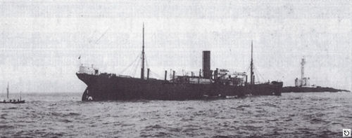
© by kind permission of Dr. Edward J. Bourke
| Source Publications: |
| "Dictionary of Disasters at Sea during
the Age of Steam 1824
- 1962" |
by | Charles Hocking |
| London Stamp Exchange 1989 - ISBN: 0948130474 | ||
| "Shipwreck
Index of Ireland" | by | Richard & Bridget Larn |
| Lloyd's Register - Fairplay Ltd 2002 - ISBN: 1900839970 | ||
"Shipwrecks
of the Irish Coast 1105 – 1993" | by | Dr. Edward J. Bourke |
| Edward J. Bourke 1994 - ISBN: 0952302705 | ||
|
"Shipwrecks
of the Irish Coast 1582 – 2000" |
by | Dr. Edward J. Bourke |
| Edward J. Bourke 2000 - ISBN: 0952302721 |
| |
Last update - 15-Oct-2004
|
|
A page from "www.irishwrecksonline.net" ©